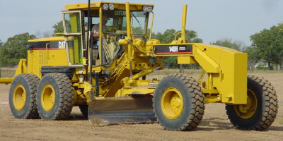
About mmGPS
We use Millimeter GPS+ because it is the perfect tool for layout, rough grading, fine grading,
blue-topping(in areas we can not use machine grade control) and
other fine tolerance work.
With Millimeter GPS+, the days of lost productivity, using stringlines
or running manually off of hubs,
are over.
Millimeter GPS+ combines the advantages of laser(multi-user & high
vertical accuracy) with GPS
(multi-user & 3D) into one versatile, accurate and easy to use system. This technology has improved
our grading accuracy up to 300% over existing
3D-GPS machine systems.
Unlike any other laser technology, the PZL-1 transmitter sends out a
wall of light 33’ tall and up to
2000’ in diameter.
We simply add the PZS-MC machine control sensor or PZS-1 rover sensor
to our existing GPS+ system,
and watch our GPS vertical accuracy shrink
down to numbers we never imagined before.
When we need more coverage? We can link up to four PZL-1 transmitters
for a total of 8000’
horizontally and 132’
vertically. Unlike other systems, multiple machines and man
rovers run off one transmitter, there is no limit!
Benefits
Up to 300% more accurate than standard GPS
Large working range: up to 8000’ horizontal & 136’ vertical
Increased productivity - fewer passes needed to reach finish grade
Lower investment - one system works for rough & finish grade
Grade to tighter tolerances and eliminate high-cost material overruns
Moving material more than once-is a thing of the past
Finish grade 24/7 even with minimal
satellite coverage
Frequently Asked Questions(FAQ’s) about Topcon’s mmGPS
Technology What is mmGPS?
Topcon’s mmGPS is laser enhanced GNSS(Global Navigation Satellite
System). By combining the
reliability and accuracy of laser technology
with the omnipresence and convenience of GNSS 3D positioning, a more
versatile and accurate positioning solution is achieved.
Is mmGPS laser technology different from conventional
flat plane lasers?
YES. Conventional lasers emit a flat laser
plane signal. The laser sensor at the rover end of the signal,
be it man or machine, must be moved up or down to find the signal. The position of the sensor must be maintained in order to continue reading the signal from the laser transmitter. The mmGPS transmitter called the PZL-1, utilizes Topcon’s unique Lazer Zone technology. The PZL-1 emits a patented
‘fan beam’ signal with a height of 10 meters(approx. 33 feet). As long as line of sight to the transmitter
is maintained
and either the PZS-1 or PZS-MC is within the 10 meter field of view,
measurement is maintained. This is very productive because the sensor
is always in the field of view.
Is MMCS limited to using mmGPS for positioning
only heavy equipment?
NO. mmGPS is for both man and machine.
There are two sensors available, the PZS-1 and the PZS-MC.
The PZS-1 is a light weight laser sensor that mounts atop a rod and interfaces with a Topcon GNSS receiver.
The PZS-MC has a 360 degree window and is used for 3D machine control mounting atop a mast. The
GNSS antenna is part of the PZS-MC and interfaces’ with a Topcon GNSS machine control receiver.
The maximum working area for both vertical and horizontal for
a mmGPS system with, One PZL-1 transmitter will cover 10 meters(approx.
33 feet) vertically and 600 meters(approx.
1968 feet)
horizontally. Up to four PZL-1 transmitters and be
linked together increasing the vertical working
area to 133’ or 7880’ horizontally. The rovers dynamically move
from one transmitter to the next seamlessly.